Tropical Storm Harold Hits Texas Coast: Latest Updates and Impacts | Texas Tropical Storm Warning 2023
Tropical Storm Harold swept onto the South Texas coast during late Tuesday morning, marking the inaugural storm of the 2023 Atlantic hurricane season to hit the US shores.
Harold’s arrival occurred just a smidge before 10 a.m. CT (that’s 11 a.m. ET), specifically landing on Padre Island, Texas. The storm carried sustained winds reaching 50 mph, with even stronger gusts, as confirmed by the National Hurricane Center. As it proceeded, the storm brought with it heavy rain and forceful winds that continued to pound parts of South Texas, regions of Mexico, and even areas further inland, as Harold charted its course westward into the afternoon and evening of Tuesday.
Rainfall grew more intense, while winds exhibiting tropical storm force extended their reach across South Texas throughout the day. It’s vital to note that tropical storm warnings have been issued from the Rio Grande’s mouth up to Port O’ Connor, Texas. Additionally, tropical storm watches are now in effect from Port O’Connor to Sargent, Texas. The scale of this weather alert encompasses over 1 million people residing within Texas.
In the coming days, Harold is predicted to bring a deluge of 3 to 5 inches of rain to South Texas on both Tuesday and Wednesday, with certain localized areas potentially facing a heavier downpour, even up to 7 inches. Meanwhile, Mexico should brace for around 4 to 6 inches of rain. Expect the wind to remain a formidable companion, particularly in and around the point of Harold’s landfall. Here, steady winds between 40 to 50 mph and gusts topping out at 65 mph are anticipated. As the storm embarks on its inland journey through Tuesday afternoon, the wind’s vigor may diminish slightly, but the likelihood of locally disruptive gusts ranging from 30 to 40 mph remains.
The surge of water, known as a storm surge, could momentarily flood low-lying coastal areas around the Rio Grande River’s mouth, extending to Sargent, Baffin Bay, Corpus Christi, and Matagorda Bay. This surge can pose serious risks to those in its path. Moreover, the threat of powerful surf and rip currents endures along the southern Texas coastline, encompassing Tuesday’s span. In fact, there’s even a chance that the state might encounter the formation of a few tornadoes due to these conditions.
This stormy situation coincides with southern Texas grappling with one of its most scorching and parched summers on historical record. Although Harold’s rainfall may bring some respite to the drought-affected regions, it might not provide significant relief to the areas in Central Texas that are grappling with extreme and exceptional drought.
As the storm’s impact approached, Texas Governor Greg Abbott demonstrated preparedness by deploying the Texas National Guard, swift water rescue boat squads, and other critical emergency resources. In a statement, he emphasized that the state is fully ready to direct all possible resources toward South Texas in response to the impending tropical storm conditions. Governor Abbott also urged Texans to remain alert about the weather and to heed the counsel of local officials and emergency management personnel who are collaborating to ensure the safety of communities.

Taking precautions, officials closed South Beach and North Beach ahead of the storm’s arrival. The Padre Island National Seashore authorities made this call, as the seashore is situated on a barrier island just south of Corpus Christi. Correspondingly, residents of Corpus Christi were advised to exercise caution if they had to venture outdoors during the storm. They were encouraged to drive slower than usual, turn on their vehicle headlights, and stay vigilant about possible flooding, particularly in low-lying areas.
Leading up to the storm, work was visibly underway in the Corpus Christi region to prepare critical canals and drainage systems for the impending heavy rainfall. Roughly 40 miles to the northeast, Port Aransas declared a local state of disaster in anticipation of the storm’s effects. The declaration stressed that the city faces a credible threat of imminent disaster, injury, property loss, or even loss of life due to the impending tropical storm’s flooding or severe damage along the coastal beaches.
With caution and safety in mind, authorities ordered evacuations in certain areas, such as the RV Park at Naval Air Station Kingsville and voluntary evacuations in Riviera, Baffin Bay, and Loyola Beach. Meanwhile, AEP Texas, which delivers power to South Texas, took proactive steps by mobilizing crews, equipment, and other resources to be ready for any potential power outages caused by the storm.
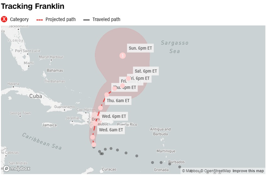
Simultaneously, another tropical storm named Franklin was gearing up to make its presence felt. Forecasted to hit Hispaniola by Wednesday, Franklin threatened the region with life-threatening flooding and the risk of mudslides. Puerto Rico was also in its trajectory, expecting heavy rainfall. At the time, Franklin sustained winds of 50 mph, hovering over the Caribbean Sea, roughly 260 miles south of Santo Domingo in the Dominican Republic. This storm was projected to take a sharp northward turn later in the day on Tuesday, setting its sights on Hispaniola for a Wednesday landfall.
The Caribbean region faced the prospects of very heavy rainfall, translating to a heightened likelihood of flash floods and mudslides, as Franklin traversed Hispaniola from Tuesday through Wednesday. The potential for isolated rainfall amounts even reached up to 15 inches. In Puerto Rico, as much as 6 inches of heavy rain was predicted through Thursday, although the island was anticipated to evade the worst of Franklin’s impact.
The Atlantic hurricane season was undoubtedly heating up, with three tropical systems forming in a span of just 24 hours over the weekend leading into Sunday. Harold was now stepping onto the stage as the fourth storm to emerge within four days. This intensified hurricane activity is a significant reminder of the need for ongoing preparedness and vigilance in the face of these powerful natural events.
By: M Z Hossain, Editor Sky Buzz Feed